 A high school class in which students learn to use ArcGIS Desktop tools, work on real projects in their community, and get college credits . . . sound too good to be true? Well, it’s not.Professor Bob Kolvoord of James Madison University in Harrisonburg, Virginia, has created the Geospatial Semester, a course that is currently being taken by more than 300 students in 12 different school districts across the state of Virginia. Students who enroll in the course have the option of receiving course credit from James Madison, a four-year public university, if their work meets Kolvoord’s standards. Because he and a colleague work directly with the participating teachers and students, their work almost always does.The most exciting thing about the Geospatial Semester to me is the way it engages students in inquiry-based learning throughout. In my experience, too many introductory GIS courses are taught in the style that I call “peas and carrots,” as in, “If you eat your peas and carrots now, you’ll get to have dessert later.” In the peas and carrots approach to learning GIS, students struggle through days and weeks of learning the mechanics of GIS in the hopes of one day actually getting to work on an interesting problem. How many classes in GIS consist of going through menu options one after another or learning how to do operations without knowing why you would use them?In Kolvoord’s approach, students spend the bare minimum amount of time learning the mechanics of GIS and begin working on interesting, real-world problems from the start. They add to their repertoire of GIS skills by working on increasingly challenging projects, some of which are taken from the book Making Spatial Decisions Using GIS (Esri Press, 2008), written by Kolvoord and collaborator Kathryn Keranen, a pioneering high school GIS educator. Making Spatial Decisions is the fourth volume in Esri’s award-winning Our World GIS Education book series designed for classroom use. A high school class in which students learn to use ArcGIS Desktop tools, work on real projects in their community, and get college credits . . . sound too good to be true? Well, it’s not.Professor Bob Kolvoord of James Madison University in Harrisonburg, Virginia, has created the Geospatial Semester, a course that is currently being taken by more than 300 students in 12 different school districts across the state of Virginia. Students who enroll in the course have the option of receiving course credit from James Madison, a four-year public university, if their work meets Kolvoord’s standards. Because he and a colleague work directly with the participating teachers and students, their work almost always does.The most exciting thing about the Geospatial Semester to me is the way it engages students in inquiry-based learning throughout. In my experience, too many introductory GIS courses are taught in the style that I call “peas and carrots,” as in, “If you eat your peas and carrots now, you’ll get to have dessert later.” In the peas and carrots approach to learning GIS, students struggle through days and weeks of learning the mechanics of GIS in the hopes of one day actually getting to work on an interesting problem. How many classes in GIS consist of going through menu options one after another or learning how to do operations without knowing why you would use them?In Kolvoord’s approach, students spend the bare minimum amount of time learning the mechanics of GIS and begin working on interesting, real-world problems from the start. They add to their repertoire of GIS skills by working on increasingly challenging projects, some of which are taken from the book Making Spatial Decisions Using GIS (Esri Press, 2008), written by Kolvoord and collaborator Kathryn Keranen, a pioneering high school GIS educator. Making Spatial Decisions is the fourth volume in Esri’s award-winning Our World GIS Education book series designed for classroom use.
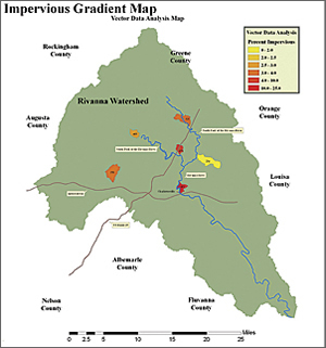
While learning GIS skills is important, the primary focus of the class is the real-world project that every student does. Each student completes a community-based research project involving spatial reasoning and decision making. Student projects have included work with The Nature Conservancy, various city and local governmental agencies, and private businesses. Their projects have included exploring the water quality in the creeks, streams, and rivers that make up a local watershed; identifying appropriate sites for cellular towers or wind turbines; and creating community evacuation plans. In the process, students develop their critical thinking, spatial reasoning, communication, and teamwork skills, while addressing a problem that’s important to them and their community. The projects require students to work cooperatively in teams and connect them to their local community as they pursue a solution to their particular problem. The solutions to these community challenges are not simple and require the students to assess the impact of their solution on different constituencies or stakeholders. As Kolvoord describes it, “[The students] get a good look at a rich tapestry of complications that challenge workers every day as they struggle with these types of problems.” Since its beginning in 2005 in four schools, more than 1,000 students have already passed through the Geospatial Semester. Kolvoord is quick to credit the teachers for the success of the program. Not only do the teachers need to develop GIS skills themselves, they also need to be expert at guiding students in doing independent projects. Kolvoord is now starting to think about how to scale the program up. He envisions it being a nationwide program one day but recognizes that the biggest challenges are limited GIS expertise in schools and the difficulty of finding organizations that will work with students on projects. However, he sees great promise in the GeoMentor program as a way to overcome these challenges. I can see it now . . . a high school class in thousands of communities across the United States, in which students learn to use ArcGIS Desktop tools, work on real projects in their community, get college credit, and work with a GIS professional as a mentor. More InformationVisit the GeoMentor program at geomentor.org and National Geographic Fund for Geo-Literacy at http://on.natgeo.com/1ptDg4Z. Register for the workshop here |

